Dapeng Zhao on Determining the 3-D Structure of the Earth's Interior
Interview for the Special Topic of Earthquakes, September 2010

 According to
our Special Topics analysis on earthquakes research over the past
decade, the work of Professor Dapeng Zhao ranks at #8 by total
cites and #5 by total papers, based on 70 papers cited a total of
1,040 times.
According to
our Special Topics analysis on earthquakes research over the past
decade, the work of Professor Dapeng Zhao ranks at #8 by total
cites and #5 by total papers, based on 70 papers cited a total of
1,040 times.
In Essential Science IndicatorsSM from Thomson Reuters, his work ranks among the top 1% of scientists in the field of Geosciences, where his record includes 97 papers cited 1,473 times between January 1, 2000 and April 30, 2010.
Zhao is currently a professor of geophysics at Tohoku University in Sendai, Japan.
![]() Please tell us about your educational
background and early research experiences.
Please tell us about your educational
background and early research experiences.
I was born in Northern China in April 1963, and studied in Department of Geology of Peking University from 1980 to 1984 as a college student. In 1985, I came to Japan and entered the Graduate School of Science of Tohoku University, got a Master's degree in 1988, and a Ph.D. in 1991.
My Master's and Ph.D. studies were about the three-dimensional (3-D) seismic structure of the crust and upper mantle under the Japan Islands. For that purpose I developed a new seismic tomography method which has been used widely by seismologists around the world.
In April 1991 I went to the Geophysical Institute at the University of Alaska, Fairbanks, as a postdoc fellow and studied the seismic structure of the Alaska subduction zone. Then I spent three years as a postdoc fellow at the Seismological Laboratory of the California Institute of Technology from May 1992 to April 1995, and investigated the detailed 3-D crustal structure in the source areas of large earthquakes, including the 1992 Landers and the 1994 Northridge earthquakes in Southern California, and the 1995 Kobe earthquake in Japan.
Then I spent two years as a research scientist at Washington University in St. Louis and about one year at the University of Southern California before I joined the Department of Earth Sciences, Ehime University, in February 1998 as associate professor. I was promoted to full professor of Ehime University in January 2003, and moved to my home school, Tohoku University, in April 2007 as a professor of geophysics.
Figure 1:
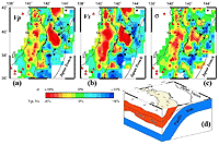
Map view of (a) P-wave and (b) S-wave velocity and (c)
Poisson’s ratio images along a cross section shown in
(d).
Download a PDF with four figures and descriptions
from Dapeng Zhao..
In the past 10 years, I have been working on the 3-D Earth structure, seismotectonics, volcanism, and geodynamics from local, regional to global scales.
![]() What first drew your interest to
earthquakes?
What first drew your interest to
earthquakes?
My first deep impression about earthquakes was in July 1976, when the Tangshan earthquake (M 7.8) occurred near Beijing and killed about 240,000 people. After I entered Peking University in 1980, I began my pursuit of studying earthquakes and hoped to predict them so as to save people from earthquake disasters.
![]() What are the main features of your earthquake
research, which has drawn much attention in Earth sciences?
What are the main features of your earthquake
research, which has drawn much attention in Earth sciences?
Seeing is believing! Earthquakes occur at some depths of the Earth's interior which is an unseen world for us human beings. Seismic tomography is a new and powerful technique to determine the 3-D structure of the Earth's interior, and it is just like a lamp to enlighten a dark room.
In the last 10-15 years my coworkers and I have been using my seismic tomography methods to study detailed 3-D Earth structures in various scales, from seismogenic fault zones, large earthquake source areas, and active volcanoes, to the Asian continent, and even the whole Earth's interior.
The high-resolution tomographic images we obtained are like high-quality photos revealing the complicated structures of the Earth's crust and mantle and the source zones of large earthquakes, which provide direct clues on the causes of large earthquakes. In particular, we found that water, fluids, and magmas in the crust and upper mantle can trigger some large earthquakes.
Recently we determined the first seismic tomography of the Moon, and we found that even the occurrence of deep moonquakes may have been affected by the structural heterogeneities in the lunar interior.
![]() One of your highly cited papers is the 2001
Earth and Planetary Science Letters paper, "Seismic structure
and origin of hotspots and mantle plumes" (Zhao D, 192 [3]: 251-265, 30
October 2001). Please tell us about your methods and findings in this
paper.
One of your highly cited papers is the 2001
Earth and Planetary Science Letters paper, "Seismic structure
and origin of hotspots and mantle plumes" (Zhao D, 192 [3]: 251-265, 30
October 2001). Please tell us about your methods and findings in this
paper.
I used the global seismic tomography method I newly developed to determine a new 3-D P-wave velocity model of the Earth's whole mantle. I found that low-velocity anomalies exist in the mantle under the major hotspot volcanoes in Hawaii, Iceland, the South Pacific, and Africa, which may reflect whole-mantle hot plumes. In addition, the plume-like low-velocity anomalies do not show a vertical pillar shape, suggesting that plumes are not fixed in the mantle but can be deflected by the mantle flow.
![]() Another highly cited paper in our larger
Essential Science Indicators database is the 2004 Physics
of the Earth and Planetary Interiors paper "Global tomographic
images of mantle plumes and subducting slabs: insight into deep Earth
dynamics," (Zhao DP, 146[1-2]: 3-34, 16 August 2004). What new data did
this paper uncover?
Another highly cited paper in our larger
Essential Science Indicators database is the 2004 Physics
of the Earth and Planetary Interiors paper "Global tomographic
images of mantle plumes and subducting slabs: insight into deep Earth
dynamics," (Zhao DP, 146[1-2]: 3-34, 16 August 2004). What new data did
this paper uncover?
"Seismic tomography is a new and powerful technique to determine the 3-D structure of the Earth's interior, and it is just like a lamp to enlighten a dark room."
In this work I further improved the whole-mantle tomographic model by adding Pdiff wave data that sample the core-mantle boundary region, and the new model uncovers some new features of mantle plumes and subducting slabs. In particular, the model shows that the subducting Pacific slab becomes stagnant in the mantle transition zone under East Asia and a big mantle wedge (BMW) forms in the upper mantle above the subducting Pacific slab and the stagnant slab.
I consider that the corner flow in the BMW and the deep dehydration of the slab may have caused the active volcanoes in Northeast China (such as the Changbai and Wudalianchi volcanoes). This is why I proposed the big mantle wedge (BMW) model for explaining the intraplate magmatism and tectonics in the East Asia region.
![]() More recently, you and your colleagues
published a paper in Tectonophysics, "Mapping the mantle wedge
and interplate thrust zone of the northeast Japan arc," (Zhao DP, et
al., 467[1-4]: 89-106, 20 March 2009). Would you talk us through
the process that led to this paper?
More recently, you and your colleagues
published a paper in Tectonophysics, "Mapping the mantle wedge
and interplate thrust zone of the northeast Japan arc," (Zhao DP, et
al., 467[1-4]: 89-106, 20 March 2009). Would you talk us through
the process that led to this paper?
Many large earthquakes (M 7.0 to 8.2) occur in the NE Japan forearc region under the Pacific Ocean from the Japan Trench to the Pacific coast. However, detailed 3-D structure under the Pacific Ocean could not be determined and the generating mechanism of the large earthquakes was less known because almost all the seismic stations are located on the NE Japan land area, and thus the suboceanic earthquakes could not be located accurately by using the conventional method. It is very important to solve this problem in order to clarify the generating mechanism of the large interplate-type earthquakes and to reduce the tsunami hazards caused by the large suboceanic earthquakes.
In this work we detected sP depth phases from the short-period seismograms from the forearc earthquakes under the Pacific Ocean recorded by the dense seismic network on the Japan Islands. Then we used the sP depth-phase data together with the P and S wave arrival times to locate the suboceanic earthquakes accurately.
A large number of P and S wave arrival times from the relocated suboceanic events and the earthquakes under the land area were used jointly to determine the 3-D structure under the entire NE Japan arc from the Japan Trench to the Japan Sea. Our result shows that the generation of large interplate earthquakes and the degree of interplate seismic coupling are controlled by the structural heterogeneity in the interplate thrust zone which can be detected by seismic tomography.
Applying the method proposed by this work to other subduction regions in the world, we will be able to better understand the mechanism of the large interplate earthquakes such as the 2004 Sumatra earthquake (M 9.2), the 1960 Chile earthquake (M 9.5), and the recent 2010 Chile earthquake (M 8.8).
![]() How much have we learned about earthquakes in
the past decade? What advances would you like to see in the future of
earthquake research?
How much have we learned about earthquakes in
the past decade? What advances would you like to see in the future of
earthquake research?
We have made great advances in earthquake studies in the past decade. Currently around the world, however, dense seismograph networks are installed in only a few areas such as the Japan Islands, Western USA, Western Europe, and the Beijing region. In the future of earthquake research, many more seismic stations will be installed in the broad oceanic regions and in those less-instrumented continental regions.
Thus the detailed 3-D structure of the crust and upper mantle in those regions will be determined, and the mechanism of earthquakes there will be clarified. The deep structure and dynamics of the Earth's interior which are the fundamental cause of the earthquakes and volcanic eruptions will also be better understood with the new and better data provided by the new generation of seismic networks that cover the Earth's surface densely and uniformly.
Advances in seismological theory will also be made to provide better tools to clarify the earthquake-generation process as well as the structure and dynamics of the Earth's interior.
Dapeng Zhao, Professor
Department of Geophysics
Tohoku University
Sendai, Japan
MOST CURRENT MOST-CITED PAPER IN ESSENTIAL SCIENCE INDICATORS:
Zhao DP, "Global tomographic images of mantle plumes and subducting slabs: insight into deep Earth dynamics," Phys. Earth Planet. Interiors 146(1-2): 3-34, 16 August 2004 with 120 cites. Source: Essential Science Indicators from Thomson Reuters.
KEYWORDS: EARTHQUAKES, SEISMIC TOMOGRAPHY, SUBDUCTION ZONE, 3-D CRUSTAL STRUCTURE, 1992 LANDERS, 1994 NORTHRIDGE, 1995 KOBE, SEISMOTECTONICS, GEODYNAMICS, 1976 TANGSHAN, VOLCANISM, CRUST, MANTLE, WATER, MAGMA, MOONQUAKES, PLUMES, HOTSPOTS, SUBOCEANIC EARTHQUAKES, P WAVE, S WAVE, NORTHEAST JAPAN ARC, SEISMOGRAPH NETWORKS.