Volker Wulfmeyer on the COPS International Field Campaign
New Hot Paper Commentary, September 2011

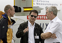
From left to right: COPS Coordinator Dr. Andreas Behrendt, the Chair of the COPS International Science Steering Committee (ISSC) Prof. Dr. Volker Wulfmeyer, and Co-Chair of COPS ISSC Prof. Dr. Christoph Kottmeier during aircraft flight planning in front of the UK FAAM BAE 146 research aircraft. |
Article: The Convective and Orographically-induced Precipitation Study (COPS): the scientific strategy, the field phase, and research highlights
Authors: Wulfmeyer, V, et al. |
Volker Wulfmeyer talks with ScienceWatch.com and answers a few questions about this month's New Hot Paper in the field of Geosciences.
![]() Why do you think your paper is highly
cited?
Why do you think your paper is highly
cited?
The paper contains results of one of the largest field campaigns on quantitative precipitation forecasting (QPF) that has been conducted yet. COPS was endorsed as a Research and Development Project of the World Weather Research Program of the World Meteorological Organization. The campaign took place in summer 2007 in southwestern Germany/eastern France. More than 300 scientists from 10 nations participated in this campaign.
The campaign addresses one of the most compelling issues in atmospheric sciences: the accuracy of the simulation and the limits of predictability of precipitation in complex terrain. This is very important for society because these regions are prone to extreme precipitation events which may eventually result in dangerous flash flood events.
![]() Does it describe a new discovery, methodology, or
synthesis of knowledge?
Does it describe a new discovery, methodology, or
synthesis of knowledge?
"Both implications for weather and climate simulations would be of great benefit for economy and society."
A speciality of COPS was the design of the instrumentation and their operation modes. Their measurements were optimized in order to observe the whole chain of events leading to the initiation and organization of convection. This includes land-surface exchange processes, atmospheric boundary layer structure as well as the development and formation of clouds and precipitation, including their microphysical properties. For this purpose, the observing systems were based on the synergy of the new generation of 3D scanning active and passive remote sensing instruments.
We achieved not only one but a series of fundamental research results:
1) Process studies:
- In connection with land-surface exchange processes we discovered a low
dependency of evapotranspiration on soil moisture. This means that the
vegetation and its state have a very important influence on the amount of
evapotranspiration.
- Orographically-induced thermodynamic flow plays a decisive role in the formation of convergence zones under all forcing conditions. Extremely complex flow patterns were observed under different atmospheric conditions. This explains to a great extent the poor performance of weather forecast models which still to date often fail to simulate the correct timing and spatial distribution of convection initiation.
- Shallow-convection likely leads to preconditioning of the lower troposphere by enhanced moistening before convection is initiated.
2) Data assimilation: Various studies demonstrate the huge potential of GPS and radar data for improving QPF. Different ensemble-based and variational techniques were tested. 3D variational approaches demonstrated good performance, particularly with respect to their operation in combination with models on the convection-permitting scale.
3) Ensemble-based modeling: High-resolution multi-model ensembles showed an improved skill forecasting single convective systems.
4) Verification of high-resolution models: For the first time in low-mountain regions, the new generation of convection-permitting models were tested and compared to models with convection parameterization. For this purpose, new fuzzy verification scores were applied. Convection-permitting models showed a clear superior skill in the fractional skill score than models with convection parameterization.
![]() Would you summarize the significance of your paper
in layman's terms?
Would you summarize the significance of your paper
in layman's terms?
Before we can expect that the prediction of precipitation can be improved, the models must be able to simulate the flow in mountainous areas. This requires a very good simulation of the heat and moisture pattern over mountains. The paper shows that it is essential to improve the model resolution in combination with better simulation of the transfer of heat and moisture into the atmospheric boundary layer. Furthermore, it is essential for QPF that more data are ingested in the models by means of data assimilation.
"The paper shows that it is essential to improve the model resolution in combination with better simulation of the transfer of heat and moisture into the atmospheric boundary layer."
There is huge information content in GPS and radar data as well as in satellite data which is by far not exploited yet. In any case, we need densified networks of new observing systems, e.g., based on water-vapor lidar, for better initialization of forecast models.
![]() How did you become involved in this research, and
how would you describe the particular challenges, setbacks, and
successes that you've encountered along the way? Where do you see your
research leading in the future?
How did you become involved in this research, and
how would you describe the particular challenges, setbacks, and
successes that you've encountered along the way? Where do you see your
research leading in the future?
I became involved as one of the initiators of the Priority Program 1167 "Quantitative Precipitation Forecasting" of the German Research Foundation. We realized quickly that a QPF research program depends strongly on the collection of new 3D data in complex terrain. Furthermore, international collaboration is essential for the deployment and operation of key instrumentation with strong aircraft support. It was a very exciting task for our institute to prepare and to realize a suitable campaign. Of course, this was only possible by excellent collaboration between leading research institutes located in the areas of interest, particularly KIT in Karlsruhe.
Future activities should focus more on the interaction between orographically-induced flow, fine structure of convergence lines, and aerosol-cloud-precipitation microphysics feeding back into the structure and organization of convection. More work on the verification of high-resolution models is necessary for focusing on variables which have not been extensively verified yet, such as boundary layer and cloud properties. Extensive work is also required on the combination of new observations, high-resolution models, and data assimilation techniques by means of ensemble-based methods. This is important for studying the predictability of high-impact weather events.
![]() Do you foresee any social or political
implications for your research?
Do you foresee any social or political
implications for your research?
There are strong implications on the development of advanced weather forecasting systems. Improved ensemble-based weather forecasts will lead to more accurate predictions including probabilistic estimates of high-impact weather. Their results will be incorporated in probabilistic flash flood forecasting systems for better warning with respect to flooding events. This includes forecast ranges from nowcasting to medium-range weather forecasting.
What is often underestimated and should further be explored is the impact of our research on regional climate simulations. We demonstrated clearly that advanced simulation of precipitation statistics requires a resolution of the order of a few km of the models. Otherwise, severe systematic errors in the simulation of precipitation are remaining. Therefore, we expect that the scientific community will realize sooner or later that our results imply the preparation and performance of a new set of regional climate simulations on the convection-permitting scale.
Corresponding improvements of both weather and climate simulations will be
of great benefit for economy and society as well as for decision
makers.![]()
Volker Wulfmeyer, Prof. Dr.
Executive Director
Chair of Physics and Meteorology
Institute of Physics and Meteorology (IPM)
University of Hohenheim
Stuttgart, Germany
KEYWORDS: CONVECTION, AEROSOL-CLOUD-PRECIPITATION MICROPHYSICS, DATA ASSIMILATION, LAND-SURFACE EXCHANGE, OROGRAPHY, QUANTITATIVE PRECIPITATION FORECASTING, THERMALLY INDUCED FLOW, VERIFICATION, DIFFERENTIAL ABSORPTION LIDAR, MESOSCALE ALPINE PROGRAM, LIQUID WATER PATH, MAP D PHASE, COMPLEX TERRAIN, DEEP CONVECTION, BOUNDARY LAYER, FUTURE PERFORMANCE, RAMAN LIDAR, VAPOR.