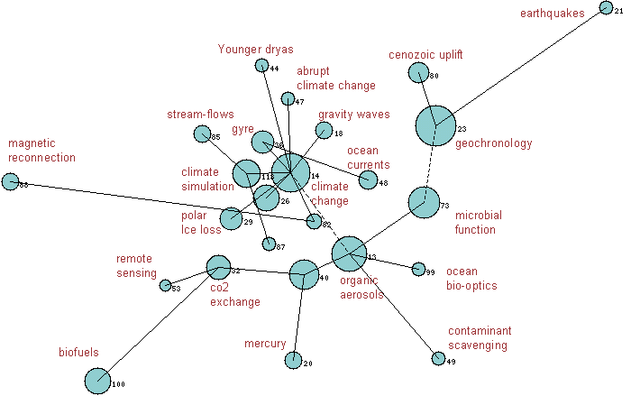
This map of Geosciences is based on research-front data for the six-year period
ending in February 2009. The map shows the major fields of Geosciences linked
together in a network based on the same principles as our research-front maps
showing highly cited papers. In the case of a field
map, we first identify all research fronts in
Essential Science IndicatorsSM
from Thomson
Reuters which were assigned to the Geosciences category based on journal.
Then the linkage between fronts is computed based on how often they are
co-cited—that is, the frequency that current papers cite the two fronts jointly.
A clustering process then groups fronts into larger aggregates. Thus, each
circle in the map represents a group, or cluster, of research fronts on a broad
topic in Geosciences. Hot fields containing concentrations of
recent highly cited papers are shown in yellow.
Annotations have been added to this map which represent the
main research themes. These appear as labels attached to specific regions on the
maps.
Additional information about Research Fronts.
Label: 32 PARTITIONING EDDY COVARIANCE-MEASURED NET ECOSYSTEM EXCHANGE; PARTITIONING EUROPEAN GRASSLAND NET ECOSYSTEM CO2 EXCHANGE; EDDY COVARIANCE NET CARBON FLUXES; IN-SITU LEAF AREA INDEX (LAI) DETERMINATION; MODIS LEAF AREA INDEX PRODUCTS Discipline: Geosciences; Agricultural Sciences Level 1 Docs: 3 Tot. Cites: 1678; Uniq. Cites: 1575 Mean Year: 2004.80
Label: 88 CURRENT SHEET STRUCTURE; UNDRIVEN MAGNETIC RECONNECTION; FAST MAGNETIC RECONNECTION; MAGNETIC X-LINE OBSERVED; CURRENT SHEET FLAPPING MOTION Discipline: Geosciences Level 1 Docs: 3 Tot. Cites: 327; Uniq. Cites: 319 Mean Year: 2005.70
Label: 87 NEW HADLEY CENTRE GLOBAL ENVIRONMENTAL MODEL (HADGEM1); NEW HADLEY CENTRE CLIMATE MODEL (HADGEM1); MET OFFICE'S GLOBAL; NEW DYNAMICAL CORE; MODEL DESCRIPTION Discipline: Geosciences Level 1 Docs: 2 Tot. Cites: 174; Uniq. Cites: 166 Mean Year: 2006.50