In the Research Front Map "
Climate Change and Species Distributions," which is
part of our Special Topics analysis of Climate Change
research over the past decade, the paper "Very high
resolution interpolated climate surfaces for global land
areas," (Hijmans RJ, et al., Int. J. Climatol.
25[15]: 1965-78, December 2005), has 262 cites. According
to
Essential Science IndicatorsSM from
Thomson
Reuters, citations to this paper now total 301 up to
August 31st of this year.
Lead author Dr. Robert J. Hijmans's record in the database includes 34
papers cited a total of 1,189 times between January 1, 1999 and August 31,
2009. Dr. Hijmans is an Assistant Professor in the Department of
Environmental Science and Policy at the University of California,
Davis.
Below, he talks with
ScienceWatch.com about this paper and the importance of
observed weather data in climate change research.
Would you please describe the significance of
your paper and why it is highly cited?
There is a strong interest in understanding and modeling the geographic
distribution of organisms as a function of climate and other factors.
Species distribution modeling (also known as environmental or ecological
niche modeling) is a particularly frequently used method in biogeography,
ecology, evolution, and conservation biology. In a species distribution
model, the climate at known sites of occurrence of an organism is used to
infer its climatic requirements and to predict its geographic range. But
there are also applications of other types of climate-driven
models—for example, in epidemiology and agriculture.
These models are used to understand geographic distributions under current
conditions, but are also used to predict distributions across space and
time. For example, to investigate the likely response of a species to
projected future climates or to reconstructed paleo-climates, or to
evaluate how well a tree species from one continent might grow somewhere in
another continent, whether as an invasive or as an economically useful
species.
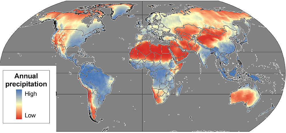
Annual
precipitation
according to the
WorldClim database.
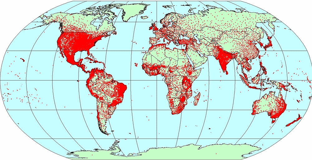
46,000 weather
stations with
precipitation data
used in WorldClim.
This type of modeling is done with climate data on a grid (raster) that can
be obtained through interpolation of observations made at weather stations.
In our paper we describe the "WorldClim" database that consists of climate
grids with a spatial resolution of 1 km2 for the 1950-2000
period. The database includes monthly precipitation and maximum and minimum
temperature. Previously available global climate data had a spatial
resolution of about 324 km2. This is rather coarse for areas
with sharp climate gradients, such as found in mountain environments.
The database is also used for statistically downscaling and calibrating
projected future climate data. Climate models do not correctly predict
current climate patterns for all areas. To circumvent this problem, one can
interpolate the modeled change in climate and apply these to the
WorldClim data to provide an estimate of future climate relative to
observed, rather than to modeled, historical conditions.
How did you become involved in this research, and
were there any particular successes or obstacles that stand
out?
We started the development of WorldClim because we needed high-resolution
climate data for our research on species distributions. We did not plan to
do this work as we were merely interested in using these data, and not in
developing the database. We started with Ecuador, then expanded our work to
cover the Americas, and having come that far we decided to do the whole
(terrestrial) world, so that this "spin-off" would become more generally
useful.
A major obstacle in this work is to get access to primary weather station
data. For most countries it remains very difficult, or very expensive, to
get access to weather data, even though these data were collected with
public funding. Fortunately, we were able to build on earlier compilations
by the Global Historical Climatology Network and the
International Center for Tropical Agriculture, among
others. Even though the total number of weather stations we used is
quite high (about 46,000 for precipitation), there are many more
stations and our coverage is rather sparse in some areas.
Where do you see your research and the broader
field leading in the future?
Much can be done to improve the interpolated climate data. Using more (and
high quality) climate station data is probably most important. In addition,
interpolation techniques can be improved, e.g. by using different
algorithms and additional co-variables. There is a growing archive of
satellite observations of weather data that could be used. Future versions
of our database will have more climate variables and also have estimates of
uncertainty.
What are the implications of your work for this
field?
Despite the broad interest in climate change, and grave concerns about it,
there appears to be an absence of political leadership to make available
the most basic data needed for such research: observed weather data. Our
accidental role in creating WorldClim suggests there is also insufficient
interest in, or support for, the compilation of detailed global geographic
databases that are needed to understand global change. This includes
climate data, but also land cover and land use and social and economic
data. WorldClim is freely available on the web and its
frequent use illustrates the importance of breaking barriers to data
access, and of compiling detailed global geographic
databases.
Robert J. Hijmans, Ph.D.
Department of Environmental Science and Policy
University of California, Davis
Davis, CA, USA
Elith J, et al., "Novel methods improve prediction
of species' distributions from occurrence data,"
Ecography 29(2): 129-151, April 2006. Source:
Essential Science Indicators from
Thomson
Reuters.
KEYWORDS: SPECIES DISTRIBUTION MODELING,
CLIMATE-DRIVEN MODELS, GEOGRAPHIC DISTRIBUTIONS, PREDICT DISTRBUTIONS,
CLIMATE DATA, WORLDCLIM DATA, PRIMARE WEATHER STATION DATA, GLOBAL
HISTORICAL CLIMATOLOGY NETWORK, INTERNATIONAL CENTER FOR TROPICAL
AGRICULTURE.