James Jackson Discusses How the Continents Deform
Interview for the Special Topic of Earthquakes, November 2010

Page: < 1 | 2 >
 For a start, Asia and India are not the
same, geologically. So these are simple questions that anyone can ask
by looking at a map: India is as flat as a pancake and all hell has
broken loose for 3,000 km north of the border. Clearly there is a
difference in the strength of the rocks, and you can use earthquakes
as a proxy to measure this.
For a start, Asia and India are not the
same, geologically. So these are simple questions that anyone can ask
by looking at a map: India is as flat as a pancake and all hell has
broken loose for 3,000 km north of the border. Clearly there is a
difference in the strength of the rocks, and you can use earthquakes
as a proxy to measure this.
The view of geophysicists from the early 1980s was that the continental lithosphere is a jelly sandwich, consisting of a weak lower crust sandwiched between a strong upper crust and uppermost mantle. The paper sets out aview that that model is generally incorrect, and that the behavior of the continental lithosphere is dominated by the strength of its upper seismogenic layer.
The earthquake evidence supported this novel point of view. The depth at which earthquakes occur correlates with the strength of the material. In India, which is manifestly strong, earthquakes continue right throughout the crust whereas in Tibet they do not.
Looking at this on a global basis, what we find is that all places where the rock is exceptionally strong are also exceptionally old. India is part of a very old chunk of Africa which broke away and then slammed into Asia. The undeformed flat centers of the continents tend to be made of ancient pre-Cambrian rocks, and are called shields. They drift around the globe causing trouble at their edges, where they bash into younger material, forming the Appalachian mountains, the Rockies, the Mackenzie mountains, and so on.
The temperature of the rock relative to its melting temperature is critically important. The old centers of the continents remain undeformed because we think the lower part of the crust there has a melting temperature of around 1,200 K because it is bone dry. The weaker younger crust melts at about 800 K, due to the presence of water.
In fact, earth scientists were mistaken about the temperature distribution in the crust and mantle anyway, partly because the effect of radioactive heating in older rocks had been underestimated. So the simple explanation to the question as to why you don't get earthquakes below the crust on continents is answered because the mantle is hotter than had been thought.
![]() I'd like to begin our discussion of papers with
your 2000 Geology paper (28: 495-8) and your 2000
Geophysical Journal International paper (143: 629-61). Both of
these give your former graduate Alessia Maggi as the lead author, and
they are about the continental lithosphere. The subtitle of the latter
is rather intriguing: "Do earthquakes really occur in the continental
mantle?"
I'd like to begin our discussion of papers with
your 2000 Geology paper (28: 495-8) and your 2000
Geophysical Journal International paper (143: 629-61). Both of
these give your former graduate Alessia Maggi as the lead author, and
they are about the continental lithosphere. The subtitle of the latter
is rather intriguing: "Do earthquakes really occur in the continental
mantle?"
For us the saga of continental earthquakes started in about 1998 when we put Alessia on the case. We felt that there was something wrong with the model that everyone had accepted for 20 years. She discovered that there are almost no earthquakes in the continental mantle, beneath the crust. To do this work we used a new method that had been developed to find the crust-mantle boundary—the authorities had gone off methods allowing geophysicists to loose off a ton of explosives!
This trick uses a seismometer on the surface to record distant earthquakes. When the P-wave hits an interface, such as the crust-mantle boundary below the receiver, the P-wave generates an S-wave. The time delay between the two allows you to see how thick the crust is. So, suddenly we knew where the boundary was.
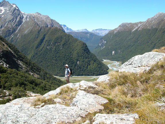
Photo 2:
"That's what I do: visualizing geology in
action."
On fieldwork in the southern Alps, New Zealand. Photo
by James Jackson. View larger image in the tab
below
Having located the boundary, these papers launched a chain of research events, and the problem was the publications could not keep up with the rate at which we developed the field. The Geophysical Journal International paper, by the way, has the data. By 2008 the field had quieted down enough for us to write a review (Jackson et al., J. Geol. Soc. London, 165: 453-65, 2008) summarizing what we had achieved. Nobody has managed to knock any holes in that one yet!
![]() What was important about your 2002 Geophysical
Journal International paper, which concerns the Caspian Basin (148:
214-45)?
What was important about your 2002 Geophysical
Journal International paper, which concerns the Caspian Basin (148:
214-45)?
This is a rather popular paper looking at the tectonics of the South Caspian Basin, which is the southern half of the Caspian Sea. What's going on here is part of the collision between Arabia and Eurasia. The basin is deep, about 1 km, and like the Black Sea it is a trapped fragment of an ocean. It's filling up with sediments from great rivers like the Volga. It's an important source of oil and gas. The accumulated sediments amount to about 10 km of sand and mud, which the oil companies could not see through.
We used earthquakes to see what's going on under the mud. We looked at all the earthquakes in the region. The situation is dynamic, and our analysis revealed what is happening now. The sea is getting gobbled up by the northern part of the Caspian which is over-riding the southern part, and the southern boundary is in turn being over-ridden by Iran. Let me point out that we did all this before GPS, and GPS has indeed demonstrated that we got the tectonics correct.
![]() And what did your 2001 Geophysical Journal
International paper tell you about the Apennine chain in Italy
(147: 475-97)?
And what did your 2001 Geophysical Journal
International paper tell you about the Apennine chain in Italy
(147: 475-97)?
Historically geologists regarded the Apennines, the backbone of Italy, as being formed from the compression of plates, like the Himalayas. That's true, but not what is happening now: instead of rising up they are falling down! A large earthquake in Naples in 1980 killed 5,000 people.
The seismology of that one is quite clear: the Apennine mountain belt is breaking up by extension that is ongoing. We do see this elsewhere: Greece, Turkey, Tibet, Nevada, and parts of China. In all those regions the faults exposed at the surface are big escarpments inclined at 45° adjacent to sediment-filled basins.
However, that's not so in Italy, where there are no basins filling with sediment. Italy has valleys that are deeply incised by river gorges. That's because Italy is high (from when it was scrunched up as recently as 2 million years ago), then it started to stretch. Italy is narrow, so the basins that did form in the interior were captured by rivers eating back from the sea.
So in Italy, instead of the great flat plains you get in Greece, you've got this landscape of gorges. This topography was completely misleading. Italy has changed a lot in recent geologic times because it has been uplifted by mantle up-welling as this paper points out. This is a definitive paper on the topography of Italy.
![]() As a last word, what is your hot tip for someone
entering this field?
As a last word, what is your hot tip for someone
entering this field?
Most information on earthquakes is in the public domain and the trick is to
recognize how it can help one to do earth science.![]()
Professor James Jackson FRS
Department of Earth Science
Bullard Laboratories
University of Cambridge
Cambridge, UK
Page: < 1 | 2 >
JAMES JACKSON'S MOST CURRENT MOST-CITED PAPER IN ESSENTIAL SCIENCE INDICATORS:
Maggi A, et al., "Earthquake focal depths, effective elastic thickness, and the strength of the continental lithosphere," Geology 28(6): 495-8, June 2000 with 139 cites. Source: Essential Science Indicators from Clarivate.
ADDITIONAL INFORMATION:
- James Jackson is featured in ISIHighlyCited.com.
KEYWORDS: EARTHQUAKES, SEISMOLOGY, P-WAVES, S-WAVES, INTERFACE WAVES, PLATE TECTONICS, CONTINENTS, SEISMOGRAMS, FAULT MOVEMENTS, WAVEFORMS, STRUCTURAL GEOLOGY, GPS, RADAR INTERFEROMETRY, JELLY SANDWICH, CONTINENTAL LITHOSPHERE, MELTING TEMPERATURE, CONTINENTAL MANTLE, CRUST-MANTLE BOUNDARY, SOUTH CASPIAN BASIN, SEDIMENTS, APENNINE CHAIN, TOPOGRAPHY.