Spotlight on Natural Resources Canada, (Part 2)
Institutional Feature, October 2010 (Page 2 of 4)

Though the GMI is an NRCan initiative, without external partners and support, it would not enjoy the impact that it does. "It's a Canadian mining industry initiative," says Laverdure, "and by all of us aligning and focusing ourselves in the endpoint of producing metals safely, clean water, and inert sand—mining activities will continue to support the livelihood of all Canadians while being safe for the environment; we will arrive there one day!"
FOREST FIRES: EARLY-WARNING SYSTEMS & IMPLICATIONS FOR CLIMATE CHANGE
The Forest Fire Research Projects of the Canadian Forest Service (CFS) takes on a wide variety of activities related primarily to wildland or forest fires, including fire danger-rating systems, carbon emissions, and the role of fire in climate change. Dr. Mike Flannigan, a Research Scientist in this division, notes that members of this group work worldwide.
The UN has taken aspects of Canada's fire danger-rating and early-warning systems to use for global models. "This is the work of Dr. Bill de Groot, and it's for the UN International Strategy for Disaster Reduction," Flannigan explains.
"After the devastating tsunami of Boxing Day 2004, the UN wanted to start this early warning system for all types of natural disasters—including forest fires. So that's how our group got started, and, as it turns out, the Canadian Forest Fire Danger Rating System," he continues. "This system takes a look at fire weather and behavior, and is used by fire-management agencies across Canada and in many other countries in the world.
"...indications are that there's going to be an increase in fire activity in Canada and Alaska, and possibly very significant increases." -Mike Flannigan
"How it works is we look at the current fire weather and fire danger, and then we use numerical weather products, computer simulations—the same thing weather forecasters on TV use—to calculate the fire weather index for the next three days. The system is currently under development, and hopefully will be up and running in the next six months globally."
Products for the global early warning system are first prepared on the development site at the Great Lakes Forestry Centre.
On that site, Global maps illustrating codes and indices from the Canadian Forest Fire Weather Index System are presented: the Fire Weather Index (FWI, indicating fire intensity and general fire danger), the Fine Fuel Moisture Code (FFMC, potential for fire starts), Duff Moisture Code (DMC, forest floor moisture), Drought Code (DC, long term drying), Initial Spread Index (ISI, fire spread rates), and Buildup Index (BUI, overall fuel dryness). All codes and indices are scaled from Low fire danger (blue) to Extreme fire danger (red).
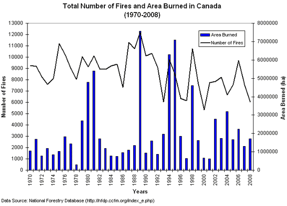
Photo 3:
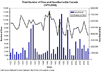
"Total number of fires and area burned in Canada
according to statistics contained in the National Forestry Database."
View larger image, complete description, and source
credit in tab below.
Fire is an important phenomenon in Canada. According to Flannigan, Canada has about 9,000 fires a year, which burn about two million hectares of land—about half the size of Nova Scotia. Although fire is a part of the natural system, it does threaten communities, and so Canada spends about 800 million dollars per year on direct fire-management costs.
"Global figures are hard to come by," Flannigan says, "but we get about 350 million hectares burned a year, which is about the size of India. This includes all fire activity—wildfires, deliberate-set, etc. Most are due to human activity, and Africa, Australia, and South America are the real hotspots. We don't have an accurate count of the number of fires globally per year because it's very hard to get data on that, and the data we do have is from satellites so it's an approximation, but at least we have an idea how much area burned."
Fires like this are a huge economic drain, as well as being a climate change issue. Flannigan has worked on estimating what future area burned in Canada might look like, and what the implications might be, in his highly cited paper, "Future area burned in Canada," (Flannigan MD, et al., Climatic Change 72[1-2]: 1-16, September 2005).
"What that paper did was look at historical area burned, fire weather indexes, as well as meteorological variables to see how much variability in the area burned we could explain using these variables," Flannigan explains, "We found that, at the time, surprisingly, temperature was a very good indicator of area burned at temporal scales of a month or longer and over larger pieces of real estate area."
SO WHY IS TEMPERATURE SO IMPORTANT?
There are three reasons. The first is that when it gets warmer, the fire season gets longer. Secondly, when it's warmer, there is more lightning activity, which causes most of the area burned. The last one is when it's warmer, there is greater evapotranspiration—evaporation and trees transpiring—so unless precipitation increases significantly, the fields will be drier, and fires will start and spread easier.
"So we took this data and combined it with general circulation models of how much area might be burned in the future, and the results suggested doubling," says Flannigan. "Right now, about two million hectares of land burn in Canada per year. In the future, it may be four million. Now, this doesn't mean that every year is going to be a bad fire year. But it means that, on average, we're going to have more bad fire years. There will be the wet years that come along, but fire is going to be a real problem.
"Since the 2005 paper, I've done some work with colleagues and for Alaska and Northwest Canada, and we've come up with numbers, using a slightly different model, of three to five and half times increase in area burned. These are best guesses because no one knows the future; these are based on results from models we use today and these models are not perfect, so when you project that in the future, there is more uncertainty. But indications are that there's going to be an increase in fire activity in Canada and Alaska, and possibly very significant increases.
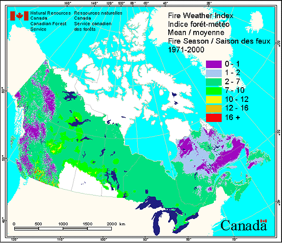
Photo 4:
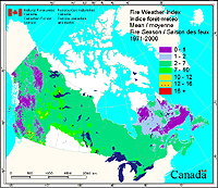
"This map displays the mean Fire Weather Indices across
Canada for the fire season (April through September) as calculated over a
30-year period from 1971 to 2000."
View larger image, complete description, and source
credit in tab below.
"One of the concerns with climate change is there may be a threshold decline where things just go off the rails and get much worse than we expect. Presently, as I mentioned earlier, we spend 800 million dollars in Canada alone on fire management costs, and we're a very efficient organization. But with climate change and more ignitions we may be reaching a limit of our effectiveness."
Flannigan says there are four factors that influence fire. The first is the fuel type: grasslands or forests, wet or dry. The second is ignition agents, whether human in origin or lightning. The third is the weather: hot, dry, sunny, windy conditions are ideal for fire spread. The fourth aspect is people. "We put fires out, but also we have accidental fires and arsonists. We're a confounding factor, a social factor. Land conversion in Africa, or even the burning of stubble on agricultural land, it's all part of the fire matrix."
Fire plays a potentially critical role in climate change, due to the release of greenhouse gases. Flannigan's group is doing some research on fires in peatlands, which are significant reservoirs of carbon, that during drought, will dry out and burn.
"Work done in Indonesia suggested that when they burned their peatlands, it was equivalent to 20% of global fossil fuel emissions for one year. The peat reserves in Canada and Siberia are at least 30 times larger," Flannigan says, "It's a real problem for putting these fires out because they can burn so deep and smolder very slowly, even through the winter on occasion.
"These peatland fires would potentially release significant greenhouse gases, making the planet warmer, and the warmer it gets, the more fires we get—it's a positive feedback. Eventually if you burn all the peatlands there'd be nothing left to burn, but in the short term, it would be a significant input, and, of course, being out of peatlands would be bad for biodiversity, etc."
The Natural Sciences and Engineering Research Council of Canada (NSERC) has given Flannigan's group funding to study peat fires, to understand when peatlands are vulnerable to burning and how much would burn.
Flannigan has also requested funding from NSERC to model fuel moisture. "We're working towards building an enhanced Canadian forest fire danger rating system, and we're updating, enhancing, expanding the system," he explains.
"Fuel moisture is one of the critical elements. We're seeing if we can do a better job of estimating fuel moisture, which is the capstone of the whole fire process because it dictates whether a fire will start or not and dictates if and how fast the fire will spread."
Work like this is very much multidisciplinary in nature. For example, the peat fire studies employ a peatland ecologist (Dr. Merritt Turetsky from the University of Guelph), a hydrologist (Dr. Mike Waddington from McMaster University), and fire experts (Drs. Mike Wotton at NRCan-CFS and the University of Toronto and de Groot and Flannigan at NRCan–CFS and the University of Alberta).
Flannigan is also involved in some projects for NASA, and has been historically involved with the International Geosphere-Biosphere Programme. "There's a fair bit of activity going on at national and international levels, depending on the problem and the funding available," he concludes.
EARTHQUAKES: MONITORING AT HOME & ABROAD
One might not instantly associate Canada with earthquakes, but the Geological Survey of Canada (GSC) records approximately 4,000 earthquakes annually in Canada—in general, about 50 of these earthquakes can be felt by people. Although the western part of Canada, along the plate boundaries, tends to be the most active, there is considerable activity in the east as well.
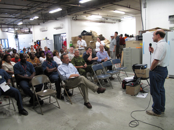
Photo 5:
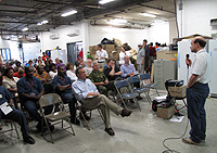
"Natural Resources Canada's Dr. Maurice Lamontagne
delivers a presentation on earthquake awareness to Canadian Embassy Staff
in Haiti."
View larger image, complete description, and source
credit in tab below.
According to Dr. Maurice Lamontagne, a seismologist in NRCan's Earth Sciences Sector, these types of earthquakes are called intraplate earthquakes, because they occur far away from plate boundaries, and they can be just as large and destructive as those that occur on plate boundaries.
"For example," he says, "we have an area not too far from Quebec City called the Charlevoix Seismic Zone, and it's one of the most active in Eastern Canada. We've had a history of about five magnitude 6 quakes in this area. There was one in 1663; we think its magnitude was approaching 7 on the Richter scale. The idea that intraplate activity is not as dangerous as plate activity is simply not true, because there are pockets of activity where the risk is higher, such as Charlevoix."
The June 23, 2010 earthquake in Eastern Canada was another such example of an intraplate earthquake, this one in the Western Quebec Seismic Zone, which covers from Montreal up the Ottawa River to the Temiskaming region at the border of Quebec and Ontario. "We've had up to 6.2 magnitude earthquakes in the past, so we know there's a potential for fairly large earthquakes in this region," explains Lamontagne.
"But on June 23rd, it was a magnitude 5 that struck about 60 kilometers northeast of Ottawa. It was felt by people here in Ottawa, including by myself, and it was felt in Montreal as well, even down south into the US. There was some damage to chimneys, but the most dramatic impact was the landslides—one of the largest landslides was triggered about a day later."
StatChart
StatChart
Total number of fires and area burned in Canada according to statistics contained in the National Forestry Database.
Credit: © Department of Natural Resources Canada. All rights reserved. USED WITH PERMISSION.
Fireweather
Fireweather
This map displays the mean Fire Weather Indices across Canada for the fire season (April through September) as calculated over a 30-year period from 1971 to 2000.
Additional Information:
The Fire Weather Index is a component of the Canadian Forest Fire Weather Index (FWI) System. It is a numeric rating of fire intensity. It combines the Initial Spread Index and the Buildup Index. It is suitable as a general index of fire danger throughout the forested areas of Canada.
More information about the Canadian Forest Fire Weather Index (FWI) System and Fire Weather Normals is available online at the Canadian Wildland Fire Information System website.
Credit: © Department of Natural Resources Canada. All rights reserved. USED WITH PERMISSION.
Natural Resources Canada's Maurice Lamontagne
Natural Resources Canada's Maurice Lamontagne
Natural Resources Canada's Dr. Maurice Lamontagne delivers a presentation on earthquake awareness to Canadian Embassy Staff in Haiti.
Credit: © Calvin Andrews, Department of Natural Resources Canada. All rights reserved. USED WITH PERMISSION.